Generation of Folded Terrains from Simple Vector Maps
Résumé
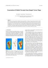
While several terrain generation methods focused on plausible watersheds, the fact that most mountains should not be isolated but rather be part of wider scale mountain ranges was seldom considered. In this work, we present the first procedural method that generates folded terrains from simple user input, in the form of some sparse peak distribution on a vector map. The key idea is to infer possible continental plates from this distribution and to use simplified plate tectonics to generate relevant terrain folds. The resulting terrain with large-scale folds, computed in real-time, can be further refined using standard erosion simulation. This leads to detailed terrains with plausible mountain ranges that match the peak distributions and main rivers specified on simple vector maps.
Fichier principal
 2015__Michel__Generation_of_Folded_Terrains_from_Simple_Vector_Maps.pdf (6.21 Mo)
Télécharger le fichier
2015__Michel__Generation_of_Folded_Terrains_from_Simple_Vector_Maps.pdf (6.21 Mo)
Télécharger le fichier
Origine : Fichiers éditeurs autorisés sur une archive ouverte
Loading...