Terrain Modeling from Feature Primitives
Résumé
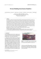
We introduce a compact hierarchical procedural model that combines feature-based primitives to describe complex terrains with varying level of detail. Our model is inspired by skeletal implicit surfaces and defines the terrain elevation function by using a construction tree. Leaves represent terrain features and they are generic parameter-ized skeletal primitives such as mountains, ridges, valleys, rivers, lakes, or roads. Inner nodes combine the leaves and subtrees by carving, blending, or warping operators. The elevation of the terrain at a given point is evaluated by traversing the tree and by combining the contributions of the primitives. The definition of the tree leaves and operators guarantees that the resulting elevation function is Lipschitz which speeds up the sphere tracing used to render the terrain. Our model is compact and allows for the creation of large terrains with a high level of detail using a reduced set of primitives. We show the creation of different kinds of landscapes and demonstrate that our model allows to efficiently control the shape and distribution of landform features.
Fichier principal
 TerrainModellingFromFeaturePrimitives_PrePrint.pdf (26.67 Mo)
Télécharger le fichier
TerrainModellingFromFeaturePrimitives_PrePrint.pdf (26.67 Mo)
Télécharger le fichier
Origine : Fichiers produits par l'(les) auteur(s)
Loading...