Sensor Data Fusion For Hazard Mapping And Piloting
Résumé
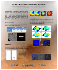
Autonomous landing on Mars, Moon or asteroids may require a Hazard Detection and Avoidance (HDA) system on-board the lander. Past studies on HDA dealt with the use of camera or LiDARs separately to detect dangerous slopes, boulders and shadow areas. The present work, performed in the frame of an ESA TRP, proposes to use jointly a camera and a LiDAR to take advantage of each while mitigating their drawbacks, consequently improving the HDA performances. Various algorithmic solutions and sensor configurations are proposed and tested in the Mars and asteroid landing cases.
Fichier principal
 fusion_poster_IPPW13_v3.pdf (9.83 Mo)
Télécharger le fichier
ippw13_abstract_fusion_final.doc (271.5 Ko)
Télécharger le fichier
ippw13_abstract_fusion_final.pdf (114.71 Ko)
Télécharger le fichier
fusion_poster_IPPW13_v3.pdf (9.83 Mo)
Télécharger le fichier
ippw13_abstract_fusion_final.doc (271.5 Ko)
Télécharger le fichier
ippw13_abstract_fusion_final.pdf (114.71 Ko)
Télécharger le fichier
Origine : Fichiers produits par l'(les) auteur(s)
Origine : Fichiers produits par l'(les) auteur(s)
Origine : Fichiers produits par l'(les) auteur(s)